Municipality of Oberbillig
The old fishing and shipping village of Oberbillig is located opposite the confluence of the Sauer and Moselle, around 15 km above Trier. The community of Oberbillig has around 1,000 inhabitants today. The place name "Billich" was first documented in 965. The history of Oberbillig is closely linked to that of the Luxembourg town of Wasserbillig. Although separated by a river, both communities formed one community. The passenger and car ferry on the German-Luxembourgish Upper Moselle, the motor ferry "Sankta Maria", maintains the direct connection between the two communities today, as in many centuries before.
Agriculture and viticulture have always been the economic basis of the population. River navigation, which was carried out by boatmen from Oberbilliger, was also important. Even today, Oberbilliger river boatmen are on the move on the European waterways. Signs pointing to the long-standing tradition of shipping can still be found on a large number of residential buildings. Oberbillig is still one of the few Moselle communities that openly face the river.
The community also continues the tradition of fishermen and boatmen with the House of Fisheries. The main building, built at the end of the 19th century, is built in the style of a "Trier single house" and has been given an even more distinctive, regionally typical appearance through the conversion. The mobile flood protection built in 2002 takes this into account, which means that the attractive connection to the Moselle is not lost.
Sights - e.g.

Heraldry (Heraldry)
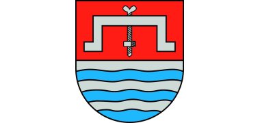
The coat of arms shows a silver grape press in a divided shield at the top in red and is divided five times in waves from silver and blue at the bottom.
The grape press points to viticulture. For centuries, Oberbillig was a branch of the Luxembourg parish of Wasserbillig. From the files in the Koblenz State Archives we can see that the community of Oberbillig was separated from the Luxembourg community of Wasserbillig only a hundred years ago, between 1843 and 1866.
In order to capture this historically significant past in the municipal coat of arms of Oberbillig, the location of the municipality on the Moselle is represented by the lower half of the shield divided five times in a wavy manner, which in the type of division and in its colors is reminiscent of the Luxembourg coat of arms, which ten times (but not in a wavy form) shared by silver and blue.


